Redefining What’s Possible in Reality Capture with Tersus MVP S1 and S2 SLAM LiDAR
Register Here
Session 2: 12:00p-12:45p MDT, April 8th
SORRY, SESSION 1 IS FULL.
Register to watch on demand
Wednesday, April 8th, 2026
10:00a-10:45a MDT or 12:00p-12:45p MDT
Redefining What’s Possible in Reality Capture with Tersus MVP S1 and S2 SLAM LiDAR
3D scanning and SLAM LiDAR technologies are evolving quickly, with new systems entering the market every year. While many solutions promise fast reality capture and digital twin workflows, the real challenge is understanding which tools deliver reliable and repeatable results, and where they fit best in real-world projects.
In this webinar, we’ll explore practical 3D scanning workflows using the Tersus MVP S1 and MVP S2 RTK SLAM LiDAR scanners. We'll discuss how different scanning systems are designed for different types of environments, what separates lightweight handheld scanners from higher-performance mobile platforms, and how to determine the right tool for the job.
The MVP S1 is a compact handheld SLAM scanner built for rapid reality capture in tight or complex environments, combining LiDAR, RTK positioning, and panoramic imaging in a lightweight system. The MVP S2 is designed for larger mapping projects and can operate handheld or in backpack mode, delivering higher-density point clouds and extended coverage. Both systems are powered by Tersus’ proprietary SLAM algorithms, engineered for stability, residual control, and clean geometry. In a market where many scanners use similar hardware components, the performance of the SLAM engine is often what determines the quality and reliability of the final point cloud. Tersus’s solutions provide clean data without fuzzy guesswork, with minimal drift, and no costly budget-depleting processing fees.
Using real datasets from field projects, we’ll walk through how SLAM scanners can be used to quickly capture complex environments, generate accurate point clouds, and support downstream workflows for surveying, engineering, and infrastructure documentation.
A Practical Look at 3D Scanning in the Field
3D scanning and SLAM LiDAR technologies are evolving quickly, with new systems entering the market every year. Many promise fast reality capture and digital twin workflows, but the real challenge is understanding which tools deliver reliable and repeatable results.
This webinar focuses on how these systems perform in real projects and how to choose the right tool for the job.
What You’ll Learn:
How SLAM scanners perform across different environments
The tradeoffs between speed, accuracy, and coverage
When to use handheld versus mobile systems
What to expect from SLAM data before processing
How to evaluate scanners beyond specs
ABOUT TERSUS GNSS SLAM SCANNERS
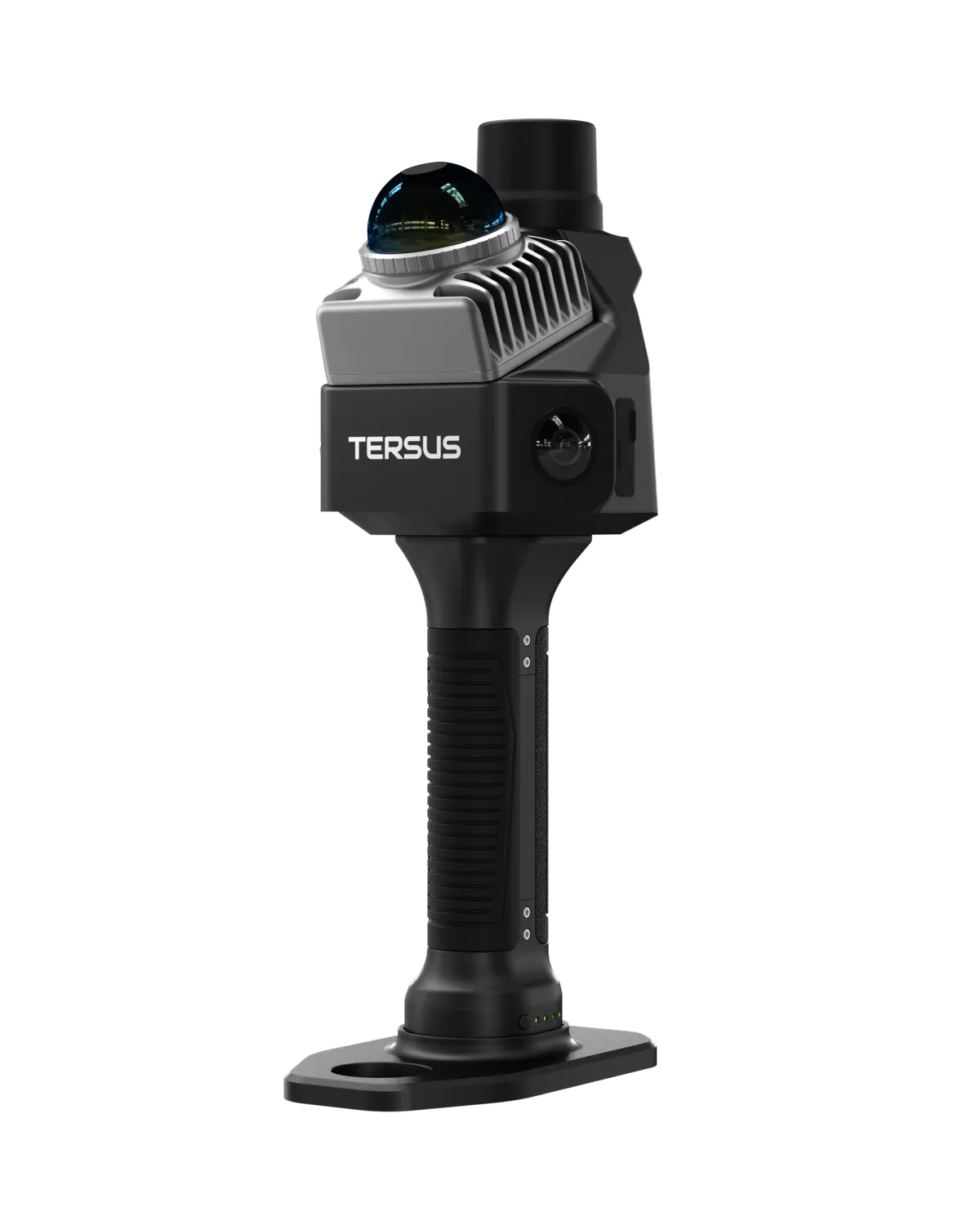
MVP S1: Built for Tight and Complex Environments
The MVP S1 is a handheld SLAM scanner designed for fast data capture in confined or complex spaces. It combines LiDAR, RTK positioning, and panoramic imaging in a compact form factor, allowing users to move through a site and collect structured data in a single pass.
It is well suited for:
Utility corridors and hard to access areas
Interior spaces and facilities
Manholes and underground structures
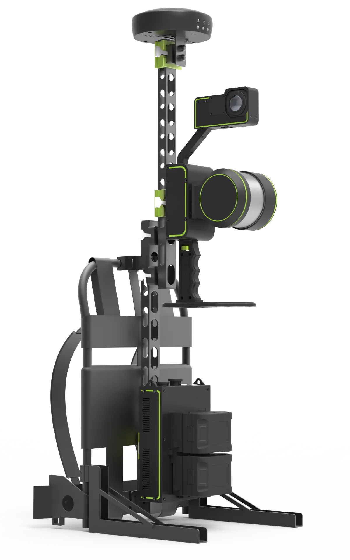
MVP S2: Built for Coverage and Scale
The MVP S2 is designed for larger mapping projects where coverage, range, and point density matter. It can be used handheld or in backpack mode, allowing teams to capture more area while maintaining consistent data quality with minimal drift.
It is well suited for:
Road and rail corridors
Construction sites
Large facilities and campuses